29.10.05

கடலை வசக்குதல்

26-12-2004 அன்று தாக்கிய வீங்கலை நமது நீண்ட கடற்கரை பற்றிய நம் மனப்போக்கு குறித்த கேள்வியை முன்னிலைப்படுத்தியுள்ளது. இதுவரை கடலை ஒரு மீன்தொட்டியாகவே நாம் கருதி வந்துள்ளோம். ஒரு வலிமையான தேசத்தைக் கட்டி எழுப்புவதில் ஒரு நீண்ட கடற்கரைக்குள்ள உள்ளாற்றலை நாம் புரிந்து கொள்ளவில்லை. வீங்கலை இந்த நிலையை மாற்ற வேண்டும்.

கடந்த நூற்றாண்டுகளில் உயர்சாதியினர் கடற்பயணம் மேற்கொள்வது அவர்களது சாதிநீக்கத்தில் முடிந்துள்ளது. காந்தியும் இராமானுஜமும் இத்தடையைப் புறங்காண வேண்டியிருந்தது. இச்சூழலில் நம் நாட்டில் கடல் வாணிகம் செழித்து வளர முடியாத நிலையால் ஐரோப்பிய வாணிகர்களுக்கு நம் நாட்டினுள் நுழைய எளிதான வழியை அழைத்துக் கொடுத்து அவர்கள் நம் ஆண்டைகள் ஆக முடிந்தது. நம் கண்ணோட்டங்களை மாற்றி விலைமதிக்க முடியாத நம் கடற்கரைக்கு உரிய மதிப்பை அளிக்க வேண்டிய ஒரு வாய்ப்பை வீங்கலை வழங்கியுள்ளது.

அண்மைக் கடந்த காலத்தில் கடற்கரையிலிருந்து 500 மீட்டர்கள் எல்லைக்குள் கட்டுமானங்களைத் தடைசெய்யும் ஆணையொன்றைப் பிறப்பிக்க இந்திய அரசை இசைவிக்க சூழியலாளரால் முடிந்தது. அந்த எல்லை பெருந்தொழிற் துறையினரின் நெருக்குதலால் 100 மீ ஆகக் குறைக்கப்பட்டு உச்சநீதிமன்றத் தலையீட்டினால் 200 மீ ஆக்கப்பட்டுள்ளது. அரசியலாளரின் துணையுடன் சில இடங்களில் கடலோரத் தடைச் சுவர்கள் கட்டுவதைக் கூட மீனவர்கள் தடுத்துள்ளனர். அங்கெல்லாம் ஓதம் மற்றும் பருவக்காற்றின் அலைகள் முட்டும் இடங்களில் வீடுகளைக் கட்டியுள்ளனர்.

கடலுக்கு இயற்கை அரணாகிய தேரி என்று குமரி மாவட்டத்தில் வழங்கப்படும் மணற்குன்றுகளை, அருமண்களுக்காகக் கச்சாவாக நேரடியாகவும் பிரித்தெடுத்தும் ஏற்றுமதி செய்ய அகற்றியதும் அவ்விடங்களில் மக்கள் குடியேறியதும் அங்கு வாழ்ந்த மக்களை வீங்கலை முன் செயலற்றவர்களாக்கி விட்டது, இப்போது கரையோர மக்களின் கண்ணோட்டத்தை வீங்கலை மாற்றியுள்ளது. கடற்கரையிலிருந்து விலகியிருக்க அவர்கள் விரும்புகிறார்கள். ஆனால் பல லட்சக்கணக்கான தங்கள் கட்டுமரங்கள், மீன்பிடி வலைகள், பிற மீன்பிடி தளவாடங்களின் பாதுகாப்பு குறித்த கவலை அவர்களை வாட்டுகிறது.

மனிதன் புனைந்த மிகப்பழைய கடல் மிதவைப் பொருள் கட்டுமரம். ஒருவர் அல்லது இருவர் மட்டும் பயன்படுத்தத்தக்க இந்த மிதவைகள் வீங்கலையின் இரக்கமற்ற கரங்களில் கொடிய ஏவுகணைகள் போல் செயற்பட்டு மனித உயிர்களையும் கட்டிடங்களையும் சொத்துகளையும் அழிப்பதில் பெரும்பங்காற்றியுள்ளன. கட்டுமரங்களை அகற்றி விட்டு படகுகள், பிற மீன்பிடி கலன்களைப் பயன்பாட்டுக்குக் கொண்டு வந்து இப்போது கட்டுமரத்தைப் பயன்படுத்துவோரை அவர்கள் வயதுக்கும் கல்விக்கும் ஏற்ப மீன்பிடிப்பு தொடர்பான தொழில்களில் திருப்பிவிட வேண்டிய காலம் கனிந்து விட்டது. இந்த இலக்கை எய்த பின்வரும் நடவடிக்கைகள் இன்றியமையாதவை.

1. தமிழ்நாட்டின் கடற்கரை நெடுகிலும் தேரிகளை மீட்டு அதன் முகட்டில் ஒரு நால்வழிச் சாலையை அமைத்து தேரியின் இரு சாய்வுகளிலும் தென்னை, பனை, தாழை, ஈந்து போன்ற பனைக்குடும்ப மரங்களையும் செடி கொடிகளையும் விறகுக்கோ, தடிக்கோ அல்லாத பிற மரங்களையும் வளர்த்தல். தேரிக்கும் உள்நாட்டு நாவிகக் கால்வாய்க்கும் இடையிலுள்ள சமநிலத்தில் தடிக்குரிய மரங்களை வளர்த்தல்.

2. கடற்கரையை அணைத்து, கன்னியாகுமரி முதல் கொச்சி வரையும் விசாகப்பட்டினத்திலிருந்து நாகப்பட்டினம் வரையிலும் சென்ற, முறையே ஏ.வி.எம். கால்வாய். பக்கிங்காம் கால்வாய் ஆகியவற்றில் பெரும்பான்மைப் பகுதி தூர்ந்து போயுள்ள நிலையில் அவற்றை முழுமையாக மீட்டல். கடலினுள் நேரடியாகக் கழிமுகங்களைக் கொண்ட ஆறுகளினுள் வழியாமல் இடைப்பட்ட நிலப்பரப்புகளிலிருந்து கடல் நோக்கி வரும் மழைநீரை இக்கால்வாய்களினுள் இயற்கையான அல்லது தோண்டிய காயல்களின் ஊடாகப் பாயவிடுதல்.

3, ஆறுகளின் கழிமுகங்களில் பொருள் போக்குவரத்து வசதியுடன் கூடிய மீன்பிடி துறைமுகங்களை அமைத்தல். தேரி முகட்டில் ஓடும் சாலையை உயர்ந்தவையும் இயன்றவரை அகன்ற இடைவெளிகளில் அமைத்தவையுமான தூண்களின் மீதமைந்த பாலங்களால் இந்த ஆறுகளைக் கடக்க விடுதல்.

4, இந்த இயற்கைக் கழிமுகங்கள் நீண்ட தொலைவுகளில் இருந்தால் இடையில் பொருத்தமான இடங்களில் சின்னஞ்சிறு மீன்பிடி துறைமுகங்களை அமைத்தல்.

இந்த ஏற்பாடுகளைச் செய்தால் மீனவர்கள் கடற்கரையிலிருந்து 500மீ தொலைவில் மட்டுமல்ல, அதனையும் தாண்டி. துறைமுகத்திலுள்ள தங்கள் வேலைக்களத்துக்கு தொல்லையின்றி வந்து செல்லத்தக்க தொலைவில் தங்களது குடியிருப்புகளை அமைத்துக் கொள்வதில் எந்தத் தடையும் இருக்காது.

குடியிருப்புகள் கடற்கரையிலிருந்து 500மீட்டக்கு அப்பால் இருக்க வேண்டும். அங்கும் வீங்கலையின் தாக்குதலிலிருந்து பாதுகாப்பானது என்று வல்லுநர்கள் நிறுவும் மட்டம் கிடைக்கவில்லையாயின் குடியிருப்புகளைத் தூண்களின் மூலம் அம்மட்டத்துக்கு மேல் உயர்த்திக் கட்ட வேண்டும். அடுக்குமாடிக் குடியிருப்புகள் விரும்பத் தக்கவை. ஆனால் மக்கள் அதற்கு இப்போது ஆயத்தமாகவில்லை. மீன்பிடி துறைமுகங்களில் உள்கூட்டமைப்புகள் முழுமையடையும் போது மீனவர்கள் உள்நாட்டினுள் சென்று அடுக்குமாடிக் குடியிருப்புகளில் வாழ முன்வருவர். எனவே இப்போது கட்டப்பட இருக்கிற நிலையான குடியிருப்புகள் மீன்பிடிக்கும் மக்களைப் பொறுத்தவரை தற்காலிகமானவையே. அனைத்துடனும் சேர்ந்து, பெரும் கப்பல்கள் எதிரெதிராகச் செல்லுமளவுக்கு அகலமும் ஆழமும் கொண்ட ஒரு கடல் வாய்க்காலையும் தோண்ட வேண்டும். குமரிமாவட்ட மீனவர் “கப்பலோடை” என்று வழங்குகின்றனர். இத்தகைய ஒரு கப்பலோடை குமரிமுனைக்குத் தெற்கில் இருப்பதாகத் தோன்றுகிறது. அது தேரி உள்நாட்டுக் கடற்கரையோர நாவிகக் கால்வாய் ஆகியவற்றுடன் சேர்ந்து எதிர்காலத்தில் வரக்கூடிய எந்தவொரு வீங்கலையும் மக்களை அடையும் முன் அது சுமந்து வரும் பேராற்றலை அழிப்பதில் பங்கு பெறும்.

எனவே நிலையான குடியிருப்புகள், மீன்பிடி துறைமுகக் கட்டமைப்புகள், உள்நாட்டு நாவிகக் கால்வாய், தேரிகள், கடற்கால்வாய் ஆகியவற்றைத் திட்டமிடும் நடைமுறையை ஒரே நேரத்தில் தொடங்க வேண்டும்.

27.10.05

Natural Calamities - Tsunami 2004 - Houses ReconstructionPolicy - Some suggestions

To

Dr. N. Lakshmanan,
Director, Structural Engineering Research Centre,
CSIR Campus, Taramani,
Chennai - 600 113.
E-mail :
director@sercm.csir.res.in , director@sercm.org , and others


Sir,

Sub: Natural Calamities - Tsunami 2004 - Houses Reconstruction Guidelines - Housing Reconstruction Policy - Some suggestions submitted.

Ref: 1) Guidelines for Reconstruction of Houses Affected by Tsunami in Tamil Nadu issued by Revenue Administration, Disaster Management and Mitigation Department, Govt. of Tamil Nadu.

2) G.O. Ms. No.172 dt.30.03.2005 Revenue (NC III) Department.

I submit my views on the above subject for your kind consideration.

Ever since my voluntary retirement on 31.08.1984 after a 24-year service as Junior Engineer in Tamil Nadu P.W.D., I practice Civil Engineering. I am involved in design, planning, supervision and construction of buildings for the past 21 years. With a team from Gandhigram Rural Institute (Deemed University) led by Dr. T. Karunakaran, the Vice-Chancellor, I visited the tsunami affected areas in Kanyakumari, Nagappattinam and Cuddalore districts and Pondicheri. Positioning of buildings, layout, and structural design of the buildings are important aspects of the envisaged habitats. We therefore observed the behaviour pattern of sea during tsunami, vis-a-vis topography and other natural features, besides infrastructural influence and interference. We put forth our views and suggestions in the light of our inference. .

We attended the "Workshop on Habitat and Shelter for NGOs involved in reconstruction activities” held on 05.04.2005 at Nagappattinam Collectorate.

I. GUIDELINES

Siting of Buildings

1. I.B.1 Natural Shielding:

In Serudhur hamlet of Nagappattinam District casuarina trees had been cut and new saplings planted. The young saplings could not resist the waves. The destruction had been massive. If usufruct trees such as coconut, cashew, scented screw pine (thazhai) whose fragrant flower has good market had been planted, they could have mitigated the damages. Longstanding trees form reliable natural shield that is preferable to firewood or timber trees. .

2. I.B. 2. Construction on raised earthen mound is costly and hence undesirable. The structure has however to be founded only on firm natural ground. Such localities require deeper foundations and hence costly. Excavation in such soils, that has not consolidated would require costly timbering or shoring. Construction of stilts to bear the buildings is obviously a better alternative. The area between stilts can serve non-residential purposes. Nonetheless, it is presumed that the natural ground level is above H.T.L.

3. Planning aspects:
2. A.3. Tsunami had lesser effects at places, where the streets ran perpendicular to the coastline. Damages had been disasters where row of houses ran parallel to the sea shore because the sheets perpendicular to coast line increases the porosity of the building complex and mitigate the ferocity of the waves in contiast to the effects of storm Forming wide gardens between the coastline and the colony with densely planted trees such as coconut, arecanut and other palmaceous trees could be ideal as a fortress to protect the habitat against wind and tsunami.

4. Construction : Dwelling Units :
3.2.A.2 Foundation : It has been stated that "when there is risk of scouring due to storm surge minimum depth of foundation 1.5m below natural ground level may be provided in coastal regions. In other places it can be 1m"
There is no specific definition to ascertain whether a site falls in the coastal region or not. Hence, it is necessary to formulate and spell out a yardstick to this effect. It could be a predetermined distance from, and elevation above the coastline at H.T.L., together with soil specification.

5. Under 3.2A.6 stepped foundation has been recommended and non stepped foundation rejected. There are frequent instances when stepped foundation on firm soils like hard gravel have given rise to vertical cracks in the absence of belt beams.. Theoretically belt beams are not required in such soils. Minor unevenness in soil conditions disturb the foundation and causes such cracks.. However, old buildings imposing heavy load on the foundation on gravelly or even clayey soils without any offset below natural ground level stay strong. New constructions having foundation without offsets below ground level have also proved safe. This is due to the friction between the rough face of the foundation and the vertical faces of the foundation trench supplementing to the bearing capacity of the soil at the bottom. It rather compares better than pile foundation, because the pile foundation secures only the friction offered along its small circumferential area, while foundations without offsets have wider area of friction on either side. In the meantime, in case of piles the sharp point of piles acts against this frictional resistance by its wedging action.

Whereas in the case of a load bearing wall foundation without offsets, built butting against the sides of the foundation trench the frictional resistance is supplemented by the bearing power of the soil at the bottom of the foundation. In this way it is possible to gain as much strength as the area of the foundation walls go, and hence even economy in materials too is plausible. The exact value of the frictional resistance offered by different classes of soils to different types of construction like R.R. Masonry, C.R. Masonry, brickwork etc. is to be ascertained by necessary research processes.

Non-plastic soils, ie. soils without sufficient cohesive property like sand, loam, alluvial soil etc. have little frictional resistance. Stepped foundation with plinth beam could be the right choice in such cases.

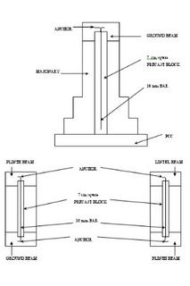
1.3.2.A.8. The vertical reinforcement proposed in fig.13 is not safe against corrosion. A better alternative would be using 7-cm precast concrete square sections with 10mm bar at the centre to anchor one end on the ground beam and the other on plinth beam. Similarly, such sections should be anchored at the plinth beam and the lintel.

Paras 3.2.A.7 - 9 require clarity. Fig.13 displays a stepped brick foundation whereas para 3.2. A.&. details a R.C. column. It is confusing whether the R.C.C. band in the middle of the bottom is a belt running throughout the length or a square block at specific points.

The method recommended in para 3.3.A.10 (Fig.13) is difficult to execute in site, because it will interfere with the brickwork if filled for every layer of brickwork and the cover and compaction cannot be assured if done after several layers of brickwork. Hence, the precast block suggested will be best suited.

7. Quality Control

Normally, wet sand is available. Even when dry sand is available the labourers make it wet because dry sand spills over mortar pans or flows through baskets on their heads and shoulders. The practice is only to mention the ratio between cement or lime and sand in terms of dry sand. Usually when the work is done under the supervision of qualified engineers the contractor and engineer understand the issue of bulkage of sand and hence due allowance is made. However, owners of buildings, or supervisors not technically qualified seldom understand bulkage issue. Such people mistake any addition of sand as a pretext for misappropriation of cement. Inasmuch as tsunami reconstruction works will be under community supervision it would create unnecessary suspicion and strain the relationship between the community and builders. Hence the sand ratio should be spelled out explicitly for both dry and wet conditions, in layman’s language.

8.Mixing of Concrete : 4.B

In the method detailed in 4.B, it will require much more labour in hand mixing to get a satisfactory degree of mixing. Usually sand and cement is mixed first and then spread on the course aggregate. The latest method is spreading sand cement mix first and spreading the metal above it. This method facilitates easy penetration of the spade through the sand cement mix to reach the bottom. A satisfactory mixture is obtained with less labour.

II.House Reconstruction Policy

1) Para 3 says "government recognizes that the fishermen people have to remain close to the sea for their livelihood." In this regard we would like to point out that since tsunami, it is imperative that the fishermen shift sufficiently away from the reach of sea waters. The habitats that remained before tsunami (B.T.) could at the best be suitable only for the storage of implement, instruments, equipment etc. Now the people having clearly understood after tsunami (A.T.) that the old locations of habitats are unsafe for habitation, they will relent if we persuade and help the fishermen to adopt fishing techniques that are conducive to living a bit away from the coastline. Breakthroughs in fishing are many in recent times. To facilitate novel fishing techniques infrastructures such as tiny, mini, minor and major fishing harbours could be built at estuaries to suit new techniques. There must be provisions for dormitories and cloak rooms for fishermen and their implement, boat service yards, fish sorting and packing facilities, net and hook service yards, fish drying yards, net drying yards, cold storage, training centres for trades relating to fishing and navigation, canteen, recreation halls, medical centres, libraries and reading rooms, weather observatory, signal posts, disaster warning centre, disaster shelter etc. In addition, steps need be taken to retrain the present catamaran fishers to adopt sophisticated technology to the adept. A model plan and a paper on behaviour of tsunami and protective measures are appended.

If such an infrastructure proposal is announced and effectively communicated to the fishing people and timely steps taken to convince them of the accruing benefits they would readily agree to reside in habitats beyond 500 m from the coastline. We request the government to announce its infrastructure policy early. The success of the housing scheme depends entirely on the affected people understanding the infrastructure policy and recognising the benefits there on.

Also, we would like to point out that most of the tsunami affected people and eyewitnesses are still averse to live in the vicinity of the sea shore any more. This is more so in case of women and children who have undergone psychological trauma. Horrors still haunt them. If anybody chooses to live close to the sea it is all because of their economic compulsions, in the wake of lack of skill and opportunity for any alternative employment. Such an indirect compulsion drives them to despair and even thoughts of suicide lingers in the minds of a few. We must prevent such grim possibilities at any cost. We request the Government of Tamil Nadu to take suitable steps in the light of the above.

2) Para 6 (a) allows the fishermen to construct new houses of their own within 200 m limit from HTL without any restriction.. This will result in non fishing people encroaching the sea shore. We request that such clauses are revised so that habitats are formed only 500m away from the coastline at HTL and all other structures demolished when all people concerned are provided with houses 500m away from the coastline
.

26.10.05

SEA SHORE PROTECTION ARRANGEMENTS INCLUDING FISHING AND INLAND NAVIGATION DEVELOPMENT AND REHABILITATION OF SEA SHORE PEOPLE AFFECTED BY TSUNAMI

1.Deciding the vulnerability level:

a)By local enquiry and observation ascertain the maximum level attained by the Tsunami wave and the highest level receding water attained.

b)Checking whether the level of incursion of the wave was uniform or regional or local.

c)If regional or local, whether an average be arrived at or regional or local levels to be adopted.

d)To eliminate the effects of human interference, a study to be made as follows:

i) To observe the nature of sea shore as to whether it projects into the sea or caves on the land.

ii) The direction in which the wave stroke the land.

iii) The existence of man made depressions on the shore.

iv) The effect of local drains into the sea.

v) Obstructions like bridges, buildings etc., close to the sea.

vi) Presence of loose objects like catamarans, boats etc., on the shore.

For this Oceanographers helped by statistics men are needed.

2. Deciding the habitat site:

a)Tracing the contour of vulnerability level and locating a site with suitable level.

b)The site to have easy connectivity inland and also to the place of fishing operations.

c)The soil at site must be suitable for construction purposes

For this purpose the personnel from Survey of India, Survey and Land records of the State Government, Revenue Department and soil mechanic experts to be deployed.

3. Deciding the type of habitat:

a)Ground floor to be left for non-residential purposes.

b)Flat system is preferable, G + 2 is desirable for safety against tsunami.

c)Buildings to be erected above columns resting on piles.

For this the choice of beneficiaries to be considered and the service of Civil Engineers, soil mechanics experts, architects to be used. Town and country planning Department and local bodies consulted.

4. Shore Protection:

a)Theri (sand dunes) to be restored throughout.

b)Earth required can be had from the inland channel to be excavated and the balance from the seashore.

c)Their top level, whether to be uniform or according to the site condition (see 1(b)).

d)The top width as to carry a four lane road is preferable, at least 2 lanes essential, in both cases with watching terraces, facing seaward and landward.

e)At river mouths bridges with minimum possible piers with maximum possible height to be provided.

f)Connection to the roads leading inland to be made by over bridges with enough head way over the banks of the inland navigation channel proposed.

g)Wind and soil erosion to be checked by planting the creeper adambu or kadambu with the special type of grass which grows on the theri, the sweet scented or screw pine (thazhai), coconut, palmyrah, dates, phoenix farinifera (eanthu) and other variety of palms, acasis, encalyptus not to be planted.

For this purpose the services of the Department of Forest and Horticulture and Ecologists and Highway engineers can be used. Soil conservation specialists are needed. Tourism department consulted.

5) Inland channel

a)In places where channel existed once and now partly or fully defunct to be restored to enough capacity for passenger and cargo ferrying during both ebb and low tides.

b)Capacity to be enough to carry inland drainage catchments not covered by streams having regular estuaries emptying directly into the sea.

c)Capacity may very according as the quantity of floodwater expected between two estuaries.

d)Desirable to collect rainwater in lagoons formed in low lying areas or artificial ones dug at intervals at suitable points.

e)Rainwater from lagoons to be drained into the channel through weirs on the landward bank with crest at high tide level so as salt water does not enter lagoon.

The lagoon M.W.L. (M.L.L) to be sufficiently high to discharge the maximum flood from its catchment with reasonable weir length.

To achieve these hydraulogists, irrigation engineers and navigation specialists to be utilised

6) Harbour and groynes

a)Mini, small, minor and major fishing harbour to be created in the rivers upstream of the estuary of rivers according to their size to be constructed with all components required.

b)If the distance between harbour be considerable tiny harbours at suitable points to be provide.

c)Each one to be provided with dormitory for fishing folk, cloak room for fishing tools, boat service yards, fish sorting and packing places, net and hook maintaining yards, net drying yards, cold storage, canteen, recreation hall, medical centre, library and reading room, weather observatiry signal etc disaster shelter, disaster warning centre etc.

In suitable points regular harbour to be built. In this regard port trust, Navigation expects, geologists, oceanographers, fishery experts, marine structure engineers, meteorologists, remote sensing and signalling specialists are necessary Altogether the coordination of the following. faculities is essential :

1. Statistics
2. Survey of India.
3. Department of Survey and land records.
4. Revenue Department
5. Building engineers
6. Architects
7. Soil Mechanics expects
8. Town and country planning
9. Local Administration
10.Highways
11. Soil conservation
12.Horticulturalist
13.Forest Department
14.Tourism
15.Ecology
16.Hydraulogy
17.Irrigation
18.Port Trust
19.Navigation
20.Geologist
21.Marine structural Engineers
22.Meteorologists
23.Remote sensing
24.Signal experts
25.Disaster Management Specialists
26.Oceanographers

FACING TSUNAMI

I. The Behaviour of Tsunami

1. Where the land projects into the sea the effect of tsunami is less.

2.Where the sea caves into the land the attack on people and property had been severe.

3. Where the habitat is located on the “theri” or beyond towards the land the buildings are least affected.

4. Where buildings are constructed removing the “theri” or in-between the “theri” and sea the devastation had been complete.

5. Wherever the low lying area created either by road or street or a stream leading to the sea exists, tsunami has entered inland through it .

6. River mouths have acted as cushions, where unobstructed and played havoc where they were obstructed.

7. River mouths protected by “theri” with covering of creeper kadambu, thazhai, and coconut trees preventing wind and water erosion have passed the energy of tsunami upsteam the river without affecting the banks of reasonable height. Pantivoikkal Odai in Kanyakumari District is an example.

8. In-between groynes sand has deposited to their entire length.

9.Theri covered by creeper Kadambu has stood like a rock fortruss against tsunami.

10. Coconut trees and casuarina have mitigateted the force of tsunami but the plain surface left after harvesting of casuarina trees has acted like a stream to receive tsunami inland.

11. Gaps left in sea walls have acted as jets letting aronomous energy carried by tsunami on habitats.

12. Catamarans, and boats left free on the shore have become powerful missiles in the merciless hands of tsunami in the destruction of human lives and property.

13. The direction of tsunami has not been uniform in adjusent places. There are incidents where in the same village tsunami has attacked from different directions, e.g. Pallam of Kanyakumari District.

14. The level to which the wave raised and level of retreat of water were different in different places.

15. The time gap between successive waves vary from 10 minutes in some places up to 2 hours in some other places.

These aspects regarding the behavior of tsunami are to be studied carefully in detail and a questionnaire prepared for that purpose.


II. Protective Measures:

1. Theri

a. Theri is a natural phenomenon throughout the sea shore. It should be restored wherever disturbed and be maintained properly.

b. The creeper kadambu and the creeper grass with needle pointed leaves are to be grown on theri to arrest erosion.

c. Plantation of sweet scented screw pine (thazhai) will also be useful in conservation of theri.

d. A 4 lane road on top of theri will enhance the usefulness of theri by serving the interest of tourism, sea shore communication and as an indirect compulsion for the proper maintenance of theri.

e. Coconut trees can be planted on both the slopes of the theri. This will also be inducive to and bear part of the cost of the proper maintenance of theri by their regular yield.

f. Plain land between theri and the inland navigation channel is to be used for growing timber wood.

2. Inland Navigation Channel:

a. A.V.M. Channel from Kanyakumari to Kochi has become mostly defunct within the limits of Tamil Nadu.

b. Buckingham Canal from Visahappattinam to Nahappatinam has mostly disappeared south of Chennai. Traceable near Mamallapuram and on both the sides of Kollidam River at its confluence at Pazhayarrai of Cuddalore District.

c. In Kottilpadu of Kanyakumari District the existing length of channel acted as a tomb of the people who lived between the sea shore and the channel. People carried by the tsunami were dumped into the ditch and burried them with the debris carried by it.

d.In Pazhayarrai, the channel, which is well beyond the habitat on to the land, have stopped the tsunami water from entering into the paddy fields by its land ward bank.

e. People of Kottilpadu want to restore the channel for its fresh water and its function as a barrier in preventing sea water displacing ground water. Pazhayarrai people also want to restore the channel.

f. These channels must be restored and new channel excavated between Nahappattinam and Kanyakumari with enough width and depth to carry on navigation even at low tide level.

g. The channel can direct the force of any future tsunami along its course and mitigate its force towards the land.

h. It will provide cheap transport of perishable cargo for short distances and non-perishable cargo for distant places.

i. Rainwater from catchments not intercepted by streams discharging directly into sea through estuaries, can be drained into this channel.

j. Flood discharge from such catchments can be allowed into the channel through lagoons formed in naturally low lying areas or artificially created ones.


3.River Mouths:

a. River mouths can be strengthened with theri protected by plantation of kadambu, thazhai, coconut and other palmeceous plants.

b. The river mouths can be developed into fishing cum transport harbors.

c. If adjacent river mouths are far apart tiny fishing harbours can be built in- between

d. Harbours should have dormitory for fishing people, cloak room for fishing tools, boat service yards, fish sorting and packing places, nets and hooks service yards, net drying yards, fish drying yards, cold storage, canteen, recreation hall, medical centre, training centre connected with fishing and navigation, library and reading room, weather observatory, signal etc., disaster warning centre, disaster shelter etc,


4. Shore line training works

a. Shore, where it caves into the land can be straightened by construction of groyens either perpendicular or inclained according to the site conditions.

b. Wooden groyens are recommended to protect our ecological balance from indiscriminate quarrying of mountains and rivers. The required timber can be obtained by plantations in the plain land between theri and inland navigation channel and the waste areas left waste in our country.


5. Sea Channel

There is a tradition that a sea channel runs south of the cape of Kanyakumari which served navigation purposes. People call it “Kappalodai” meaning “ship stream”. The excavation of such a channel wherever necessary so that navigation from one end of be sea shore of India to the other end is essential. If such a channel be excavated, it along with the theri and the navigation channel will divert most of the energy carried by any future tsunami before it reaches the places were people live. In addition it is important for cheap transport and National defence purposes.

25.10.05

TAMING OF THE SEA

The tsunami on 26.12.2004 has brought forth the question of our attitude towards our long seacoast. So far we see the sea as a mere fishpond. The potential of a long seacoast in building up of a powerful nation has not been realized. Tsunami should change the situation.

Voyage on sea by high caste people had resulted in their being outcaste in the past centuries. Gandhi and Ramanujam had to overcome this hurdle. Because of this, maritime trade could not flourish in our land which situation paved way for the easy entry of the European traders who later became our masters. Tsunami has given us a chance to change our views and pay due respect to our valuable seacoast.

In the recent past ecologists were able to persuade Indian Govt. to issue an order prohibiting structures within 500mts from the seashore. But by pressure from industrialists it was reduced to 100mts and then raised to 200mts by the help of the Supreme Court. The fishermen with the help of politicians managed even to obstruct the State Govt. from erecting sea wall in some places. They built houses where the tidal and monsoon waves washed frequently.

The removal of the natural sea fortress of sand dunes called locally “theri” in Kanyakumari District for export of the rare earth from sea shore either raw or in extracted form and subsequent colonization of the flattened shore made the people dwelling there helpless before the tsunami.

Now the tsunami has changed the outlook of the coastal fishermen. They want to be away from the seashore. But the safety of the hundreds of thousands of catamarans, fishnets, and other fishing equipments worries them.

Catamaran is the most primitive ferrying object devised by man, suitable for one or two men’s operation it has played a major part by acting as fierce missiles in the merciless hands of the tsunami in the destruction of buildings, lives and properties. It is high time to displace these catamarans by boats and other fishing vessels and diverting the people already using them in jobs connected with fishing operations according to their age and education. To this end the following steps are essential and urgent.

1. Restoration of the “theri” throughout Tamilnadu coast, forming a 4 lane road on top of it and planting coconut and other palmaceous trees and trees not meant for fuel or timber.

2. Restoration of the inland navigation channel hugging the seacoast such as the A.V.M. channel from Kanyakumari to Kochi and Buckingham canal from Visahapattinam to Nahappattinam and to excavate a new one from Nahappattinam to Kanyakumari. Local rain water not intercepted by the streams emptying directly into the sea can be drained into this channel through lagoons, either natural or artificially formed at suitable points.

3. Estuaries of streams should be made harbours mainly for fishing with provision for cargo transport. The road on top of the “theri” should be carried over these streams on high piered, long spanned bridges.

4. If the adjacent be natural estuaries far apart, tiny fishing harbours should be built at suitable points in-between.

Fishing harbours should have facilities such as dormitories for fishermen, cloak room for nets and other fishing equipments, boat service yards, recreation club, disaster shelter etc. etc.

If these provisions be made there won’t be any difficulty for the fishermen in housing their habitat not even 500mts away but at any reasonable distance they choose beyond it enabling them without any trouble to arrive their work spot in the harbour and return home.

The habitat should be beyond the 500mts limit from the shore. When the site is below the vulnerable level to be fixed by expects even at 500mts, the buildings should be elevated to the required height using columns. Flat systems of houses in desirable, but the people are not ready for it at present. When the infrastructures in the fishing harbours are complete most of the people may like to move inland and like to live in flats. Therefore the permanent habitats, which are to be erected presently, will only be a temporary one regarding the fishing people.

In addition to all these a sea channel (Kappalodai) wide and deep enough for a major ship to ferry to and fro along the whole of the Indian coast should be dug so that acting with the “theri” and inland channel it can quell most of the energy carried by any future tsunami before it reaches the people inland.

Hence the process of planning the permanent habitat and fishing harbour network and sea channel should start simultaneously.